


The new AllTrails Peak subscription offers customizable routes, real-time trail conditions, and more
Our favorite hiking app has a new flagship subscription option that adds tons of customizability to its already robust featureset. The post The new AllTrails Peak subscription offers customizable routes, real-time trail conditions, and more appeared first on Popular Science.
Few things feel worse in the hiking world than finding out you missed a great spot along the trail because of the route you chose. A few years ago, I finished a long hike only to have someone back at the trailhead ask, “Did you sit in the old bathtub and take a picture? That’s what everybody does here.” I had missed it, but I probably wouldn’t have with the new AllTrails Peak subscription (sign up for a free 7-day trial).
For the past 15 years, AllTrails has offered advanced features for hikers, including trail maps, performance tracking, real-time location tracking, and more. For many, it’s an essential companion to the traditional outdoor gear kit. The company just released its summer 2025 update, and I have been checking out the company’s new flagship AllTrails Peak membership, which adds several layers of customizability and utility to an already excellent service.
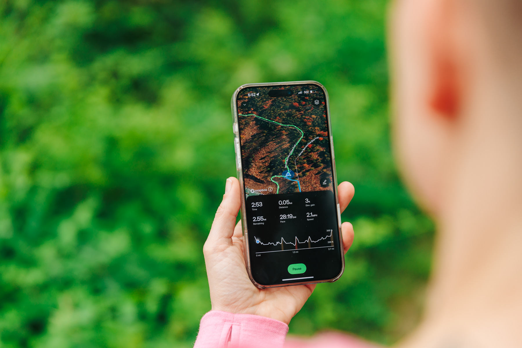
Stan Horaczek AllTrails Peak

AllTrails Base vs. Plus vs. Peak
Peak is the flagship AllTrails offering, which stacks features on top of the base subscription. Not that the standard package isn’t just fine on its own, whether you’re summitting or just sauntering. The free AllTrails Base subscription includes detailed mapping info for more than 450,000 trails worldwide. Users can also track and log hikes to share with friends or the AllTrails community. There are now roughly half-a-million points of interest on the maps as well.
Upgrading to a mid-tier Plus account adds the ability to download trail maps and preview trails in 3D to get a better feel for what it’s actually like on the ground. More importantly, it adds several crucial safety features. Real-time wrong turn alerts let hikers know if they’re getting off their intended route. The Plus subscription also allows for real-time progress sharing. As an anxious person, this is my personal favorite feature, as it allows me to cheer for and keep tabs on my partner when they’re off solo on side quests.
AllTrails Peak represents the flagship offering, and it includes everything found in both the Base and Plus plans, as well as a glut of extra customization features. Here’s a top-level rundown of the biggest upgrades:
Custom routes

Making custom routes was previously limited to the website version of AllTrails, and the process was somewhat finicky. Now, Peak members can use the app or the website to create custom routes that are downloadable to a smartphone. The app offers two options for creating a custom route: one involves tapping points on the map, while the other consists of drawing an actual line. Peak members can ask built-in AI to optimize the route in four different ways: reverse direction, make it shorter, reduce elevation gain, or take the scenic route. As the name suggests, that last option may increase the overall length of the hike in order to hit more scenic stops along the way.
With customized routes, hikers can rely on pre-mapped AllTrails routes or create their own totally from scratch while still enjoying the tracking and planning features along the way. Downloading the maps allows for simple navigation even when outside of cellular coverage.
Trail conditions

This one likely would have saved my Christmas Eve hike all those years ago. AllTrails Peak’s trail conditions integrate advanced weather data and community information directly into the app. It tracks precipitation, temperature, and snow depth and can overlay this data directly onto the map. Combined with the custom routes function, hikers can actually use this feature to avoid bad weather that they can see coming. I haven’t had the need to do so yet, but this is a very handy feature for longer treks where surprising weather can get hikers into real trouble.
A future update promises to track even more variables, including terrain conditions and mud levels. That’s useful for hikers trying not to get stuck, but can also help dissuade traffic on trails that may not be ready for the season and could be damaged by too many hikers.
Community heat map
Sometimes you want a solemn trail with very little traffic. Other times, you want the collective energy that comes with frequent on-trail encounters. This feature tracks recent user activity on trails to indicate how popular a route is right now.
Outdoor lens
This feature launches later this year, but it promises to help identify and log plants and other features found along the trail. It will note the time and location when it was spotted so users can easily go back and revisit them later. A number of other apps offer ID functionality, but the prospect of tight integration with mapping and cutting down the overall number of apps required on the trail sounds promising.
Using AllTrails Peak in the real world

My wife and I are both nursing substantial injuries at the moment, so our testing treks have been relatively chill. If you’re already an AllTrails user, you’ll find the Peak functionality integrates seamlessly with the typical experience. Of course, it’s always a good idea to make sure you have your route dialed in and downloaded before heading out to the trailhead, because connectivity can always be an issue.
I’m a fan of a new feature that’s also available with the Plus subscription that allows the app to download offline maps for an entire area all at once. If you’re going to be cruising around in a park, for instance, you can make sure that all the routes from the entire area are stored locally before heading out.
There’s no snow around here at the moment, so I haven’t been able to take full advantage of the snow depth overlay, but the temperature and precipitation overlays are great for planning purposes. I’m looking forward to the addition of more trail conditions reports, as the mud here in Upstate New York is out of hand at the moment.
So, who should sign up for AllTrails Peak?
While the free Base subscription is fine for most casual users, the Peak subscription offers benefits that hikers of just about every level can appreciate. I’m typically not much of a planner when it comes to hikes, but that may change (at least a bit) going forward. Custom routes and points of interest really make it feel like you’re getting the most out of a trail, whether for the Gram or just personal gratification. An annual membership costs $80 per year, and you can get a 7-day free trial right now. It’s a small price to pay to not miss the good parts of your favorite trails, even the old bathtubs.
The post The new AllTrails Peak subscription offers customizable routes, real-time trail conditions, and more appeared first on Popular Science.