


By Air and by Sea: Validating NASA’s PACE Ocean Color Instrument
In autumn 2024, California’s Monterey Bay experienced an outsized phytoplankton bloom that attracted fish, dolphins, whales, seabirds, and – for a few weeks in October – scientists. A team from NASA’s Ames Research Center in Silicon Valley, with partners at the University of California, Santa Cruz (UCSC), and the Naval Postgraduate School, spent two weeks […]

6 min read
Preparations for Next Moonwalk Simulations Underway (and Underwater)
In autumn 2024, California’s Monterey Bay experienced an outsized phytoplankton bloom that attracted fish, dolphins, whales, seabirds, and – for a few weeks in October – scientists. A team from NASA’s Ames Research Center in Silicon Valley, with partners at the University of California, Santa Cruz (UCSC), and the Naval Postgraduate School, spent two weeks on the California coast gathering data on the atmosphere and the ocean to verify what satellites see from above. In spring 2025, the team returned to gather data under different environmental conditions.
Scientists call this process validation.
Setting up the Campaign
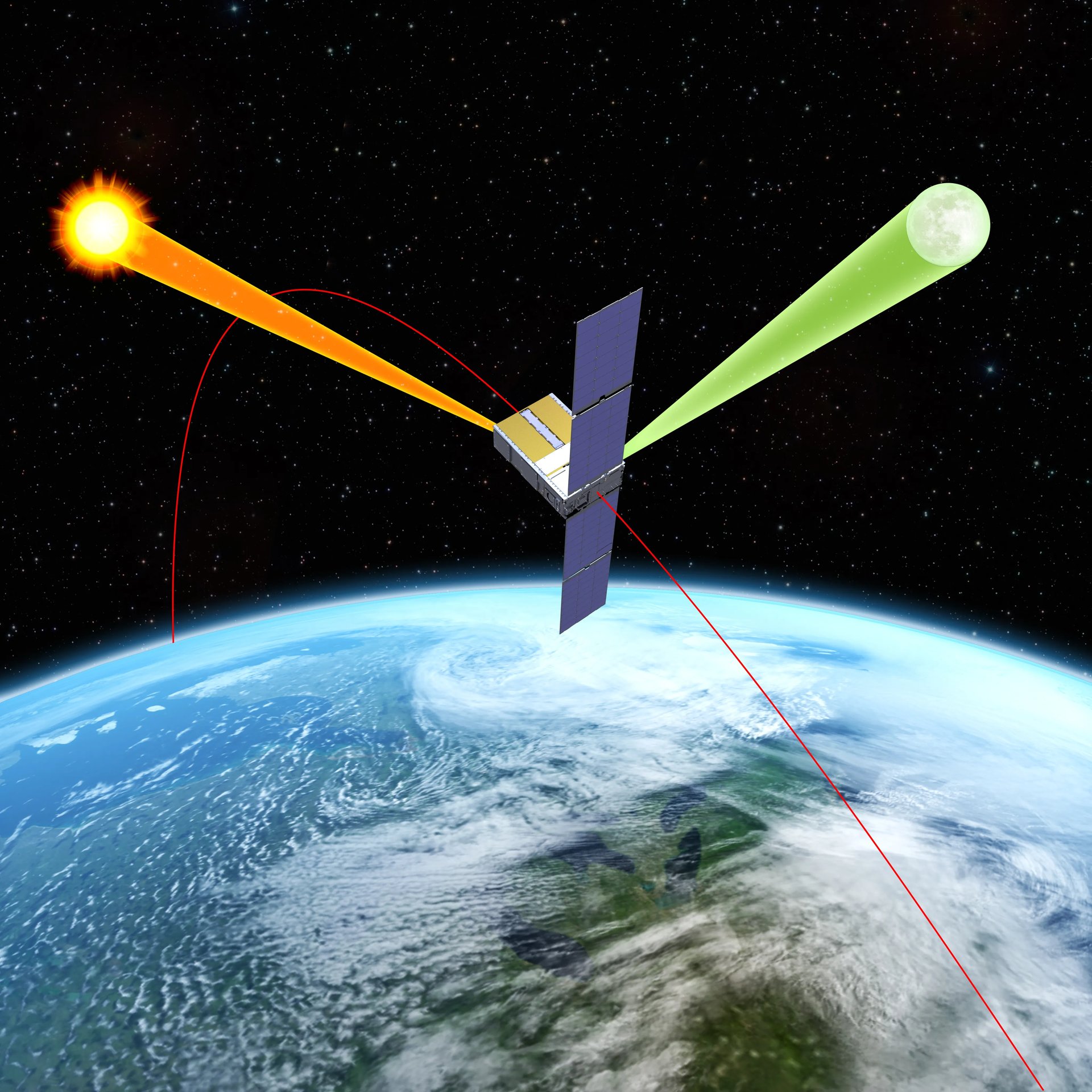
The PACE mission, which stands for Plankton, Aerosol, Cloud, ocean Ecosystem, was launched in February 2024 and designed to transform our understanding of ocean and atmospheric environments. Specifically, the satellite will give scientists a finely detailed look at life near the ocean surface and the composition and abundance of aerosol particles in the atmosphere.
Whenever NASA launches a new satellite, it sends validation science teams around the world to confirm that the data from instruments in space match what traditional instruments can see at the surface. AirSHARP (Airborne aSsessment of Hyperspectral Aerosol optical depth and water-leaving Reflectance Product Performance for PACE) is one of these teams, specifically deployed to validate products from the satellite’s Ocean Color Instrument (OCI).
The OCI spectrometer works by measuring reflected sunlight. As sunlight bounces off of the ocean’s surface, it creates specific shades of color that researchers use to determine what is in the water column below. To validate the OCI data, research teams need to confirm that measurements directly at the surface match those from the satellite. They also need to understand how the atmosphere is changing the color of the ocean as the reflected light is traveling back to the satellite.
In October 2024 and May 2025, the AirSHARP team ran simultaneous airborne and seaborne campaigns. Going into the field during different seasons allows the team to collect data under different environmental conditions, validating as much of the instrument’s range as possible.
Over 13 days of flights on a Twin Otter aircraft, the NASA-led team used instruments called 4STAR-B (Spectrometer for sky-scanning sun Tracking Atmospheric Research B), and the C-AIR (Coastal Airborne In-situ Radiometer) to gather data from the air. At the same time, partners from UCSC used a host of matching instruments onboard the research vessel R/V Shana Rae to gather data from the water’s surface.
Ocean Color and Water Leaving Reflectance
The Ocean Color Instrument measures something called water leaving reflectance, which provides information on the microscopic composition of the water column, including water molecules, phytoplankton, and particulates like sand, inorganic materials, and even bubbles. Ocean color varies based on how these materials absorb and scatter sunlight. This is especially useful for determining the abundance and types of phytoplankton.

The AirSHARP team used radiometers with matching technology – C-AIR from the air and C-OPS (Compact Optical Profiling System) from the water – to gather water leaving reflectance data.
“The C-AIR instrument is modified from an instrument that goes on research vessels and takes measurements of the water’s surface from very close range,” said NASA Ames research scientist Samuel LeBlanc. “The issue there is that you’re very local to one area at a time. What our team has done successfully is put it on an aircraft, which enables us to span the entire Monterey Bay.”
The larger PACE validation team will compare OCI measurements with observations made by the sensors much closer to the ocean to ensure that they match, and make adjustments when they don’t.
Aerosol Interference
One factor that can impact OCI data is the presence of manmade and natural aerosols, which interact with sunlight as it moves through the atmosphere. An aerosol refers to any solid or liquid suspended in the air, such as smoke from fires, salt from sea spray, particulates from fossil fuel emissions, desert dust, and pollen.
Imagine a 420 mile-long tube, with the PACE satellite at one end and the ocean at the other. Everything inside the tube is what scientists refer to as the atmospheric column, and it is full of tiny particulates that interact with sunlight. Scientists quantify this aerosol interaction with a measurement called aerosol optical depth.
“During AirSHARP, we were essentially measuring, at different wavelengths, how light is changed by the particles present in the atmosphere,” said NASA Ames research scientist Kristina Pistone. “The aerosol optical depth is a measure of light extinction, or how much light is either scattered away or absorbed by aerosol particulates.”
The team measured aerosol optical depth using the 4STAR-B spectrometer, which was engineered at NASA Ames and enables scientists to identify which aerosols are present and how they interact with sunlight.
Twin Otter Aircraft

Flying these instruments required use of a Twin Otter plane, operated by the Naval Postgraduate School (NPS). The Twin Otter is unique for its ability to perform extremely low-altitude flights, making passes down to 100 feet above the water in clear conditions.
“It’s an intense way to fly. At that low height, the pilots continually watch for and avoid birds, tall ships, and even wildlife like breaching whales,” said Anthony Bucholtz, director of the Airborne Research Facility at NPS.
With the phytoplankton bloom attracting so much wildlife in a bay already full of ships, this is no small feat. “The pilots keep a close eye on the radar, and fly by hand,” Bucholtz said, “all while following careful flight plans crisscrossing Monterey Bay and performing tight spirals over the Research Vessel Shana Rae.”
Campaign Data
Data gathered from the 2024 phase of this campaign is available on two data archive systems. Data from the 4STAR instrument is available in the PACE data archive and data from C-AIR is housed in the SeaBASS data archive.
Other data from the NASA PACE Validation Science Team is available through the PACE website: https://pace.oceansciences.org/pvstdoi.htm#
Samuel LeBlanc and Kristina Pistone are funded via the Bay Area Environmental Research Institute (BAERI), which is a scientist-founded nonprofit focused on supporting Earth and space sciences.
About the Author
Milan Loiacono
Milan Loiacono is a science communication specialist for the Earth Science Division at NASA Ames Research Center.