


.jpg)
.jpg)


NASA 3D Wind Measuring Laser Aims to Improve Forecasts from Air, Space
Since last fall, NASA scientists have flown an advanced 3D Doppler wind lidar instrument across the United States to collect nearly 100 hours of data — including a flight through a hurricane. The goal? To demonstrate the unique capability of the Aerosol Wind Profiler (AWP) instrument to gather extremely precise measurements of wind direction, wind […]

NASA 3D Wind Measuring Laser Aims to Improve Forecasts from Air, Space
Since last fall, NASA scientists have flown an advanced 3D Doppler wind lidar instrument across the United States to collect nearly 100 hours of data — including a flight through a hurricane. The goal? To demonstrate the unique capability of the Aerosol Wind Profiler (AWP) instrument to gather extremely precise measurements of wind direction, wind speed, and aerosol concentration – all crucial elements for accurate weather forecasting.
Weather phenomena like severe thunderstorms and hurricanes develop rapidly, so improving predictions requires more accurate wind observations.
“There is a lack of global wind measurements above Earth’s surface,” explained Kris Bedka, the AWP principal investigator at NASA’s Langley Research Center in Hampton, Virginia. “Winds are measured by commercial aircraft as they fly to their destinations and by weather balloons launched up to twice per day from just 1,300 sites across the globe. From space, winds are estimated by tracking cloud and water vapor movement from satellite images.”
However, in areas without clouds or where water vapor patterns cannot be easily tracked, there are typically no reliable wind measurements. The AWP instrument seeks to fill these gaps with detailed 3D wind profiles.

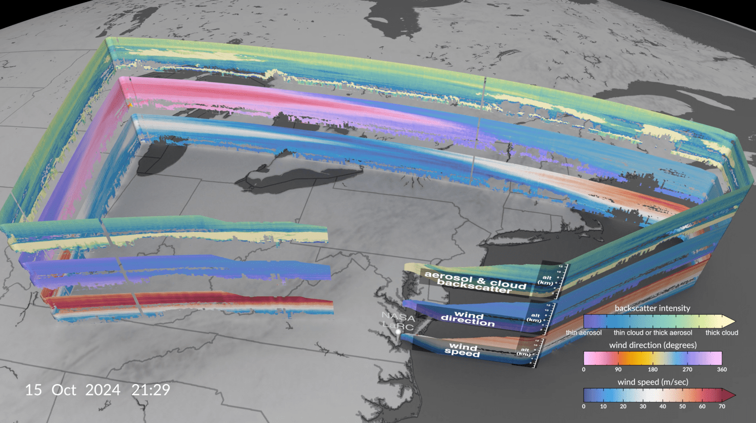
Mounted to an aircraft with viewing ports underneath it, AWP emits 200 laser energy pulses per second that scatter and reflect off aerosol particles — such as pollution, dust, smoke, sea salt, and clouds — in the air. Aerosol and cloud particle movement causes the laser pulse wavelength to change, a concept known as the Doppler effect.
The AWP instrument sends these pulses in two directions, oriented 90 degrees apart from each other. Combined, they create a 3D profile of wind vectors, representing both wind speed and direction.
We are measuring winds at different altitudes in the atmosphere simultaneously with extremely high detail and accuracy.

Kris bedka
NASA Research Physical Scientist
“The Aerosol Wind Profiler is able to measure wind speed and direction, but not just at one given point,” Bedka said. “Instead, we are measuring winds at different altitudes in the atmosphere simultaneously with extremely high detail and accuracy.”
Vectors help researchers and meteorologists understand the weather, so AWP’s measurements could significantly advance weather modeling and forecasting. For this reason, the instrument was chosen to be part of the National Oceanic and Atmospheric Administration’s (NOAA) Joint Venture Program, which seeks data from new technologies that can fill gaps in current weather forecasting systems. NASA’s Weather Program also saw mutual benefit in NOAA’s investments and provided additional support to increase the return on investment for both agencies.
On board NASA’s Gulfstream III (G-III) aircraft, AWP was paired with the agency’s High-Altitude Lidar Observatory (HALO) that measures water vapor, aerosols, and cloud properties through a combined differential absorption and high spectral resolution lidar.
Working together for the first time, AWP measured winds, HALO collected water vapor and aerosol data, and NOAA dropsondes (small instruments dropped from a tube in the bottom of the aircraft) gathered temperature, water vapor, and wind data.

“With our instrument package on board small, affordable-to-operate aircraft, we have a very powerful capability,” said Bedka. “The combination of AWP and HALO is NASA’s next-generation airborne weather remote sensing package, which we hope to also fly aboard satellites to benefit everyone across the globe.”
The combination of AWP and HALO is NASA's next-generation airborne weather remote sensing package.
kris bedka
NASA Research Physical Scientist
The animation below, based on AWP data, shows the complexity and structure of aerosol layers present in the atmosphere. Current prediction models do not accurately simulate how aerosols are organized throughout the breadth of the atmosphere, said Bedka.
“When we took off on this particular day, I thought that we would be finding a clear atmosphere with little to no aerosol return because we were flying into what was the first real blast of cool Canadian air of the fall,” described Bedka. “What we found was quite the opposite: an aerosol-rich environment which provided excellent signal to accurately measure winds.”
During the Joint Venture flights, Hurricane Helene was making landfall in Florida. The AWP crew of two pilots and five science team members quickly created a flight plan to gather wind measurements along the outer bands of the severe storm.
“A 3D wind profile can significantly improve weather forecasts, particularly for storms and hurricanes,” said Harshesh Patel, NOAA’s acting Joint Venture Program manager. “NASA Langley specializes in the development of coherent Doppler wind lidar technology and this AWP concept has potential to provide better performance for NOAA’s needs.”

The flights of the AWP lidar are serving as a proving ground for possible integration into a future satellite mission.
“The need to improve global 3D wind models requires a space-based platform,” added Patel. “Instruments like AWP have specific space-based applications that potentially align with NOAA’s mission to provide critical data for improving weather forecasting.”

After the NOAA flights, AWP and HALO were sent to central California for the Westcoast & Heartland Hyperspectral Microwave Sensor Intensive Experiment and the Active Passive profiling Experiment, which was supported by NASA’s Planetary Boundary Layer Decadal Survey Incubation Program and NASA Weather Programs. These missions studied atmospheric processes within the planetary boundary layer, the lowest part of the atmosphere, that drives the weather conditions we experience on the ground.
To learn more about lidar instruments at NASA visit:
NASA Langley Research Center: Generations of Lidar Expertise