


Sols 4518-4519: Thumbs up from Mars
Written by Susanne Schwenzer, Planetary Geologist at The Open University Earth planning date: Monday, 21st April 2025 It is Easter Monday, a bank holiday here in the United Kingdom. I am Science Operations Working Group Chair today, a role that is mainly focused on coordinating all the different planning activities on a given day, and […]
5 min read
Sols 4518-4519: Thumbs up from Mars

Written by Susanne Schwenzer, Planetary Geologist at The Open University
Earth planning date: Monday, 21st April 2025
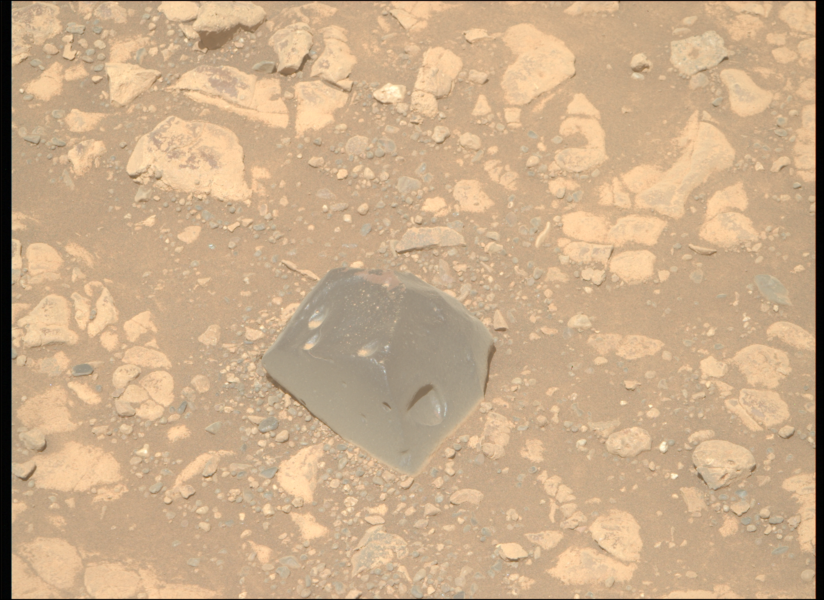
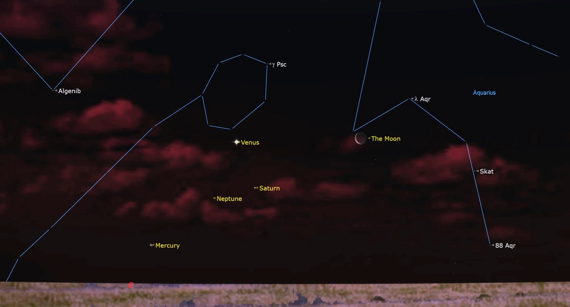
It is Easter Monday, a bank holiday here in the United Kingdom. I am Science Operations Working Group Chair today, a role that is mainly focused on coordinating all the different planning activities on a given day, and ensuring all the numbers are communicated to everyone. And with that I mean making sure that everyone knows how much power we have and other housekeeping details. It’s a fun role, but on the more technical side of the mission, which means I don’t get to look at the rocks in the workspace as closely as my colleagues who are planning the activities of the instruments directly investigating the rocks. It’s a lot of fun to see how planning day after planning day things come together. But why am I doing this on a bank holiday, when I could well be on my sofa? I just was reminded in the hours before planning how much fun it actually is to spend a little more time looking at all the images – and not the usual hectic rush coming out of an almost complete work day (we start at 8 am PDT, which is 4 pm here in the UK!). So, I enjoyed the views of Mars, and I think Mars gave me a thumbs up for it, or better to say a little pointy ‘rock up’ in the middle of a sandy area, as you can see in the image above!
I am sure you noticed that our team has a lot to celebrate! Less than a month after the publication about alkanes made headlines in many news outlets, we have another big discovery from our rover, now 4518 sols on Mars: in three drill holes, the rover instruments detected the mineral siderite, a carbonate. That allowed a group of scientists from our team to piece together the carbon cycle of Mars. If you want to know more, the full story is here. I am looking forward to our next big discovery. Who knows that that is? Well, it would not be exploration, if we knew!
But today’s workspace looks intriguing with all its little laminae (the very fine layers) and its weathering patterns that look like a layered cake that little fingers have picked the icing off! (Maybe I had too many treats of the season this weekend? That’s for you to decide!) But then Mars did what it did so many times lately: we did not pass our slip risk assessment and therefore had to keep the arm stowed. I think there is a direct link between geologists getting exciting about all the many rocks, and a wheel ending up on one of them, making it unsafe to unstow the arm. There was a collective sigh of disappointment – and then we moved on to what we actually can do.
And that is a lot of imaging. As exciting as getting an APXS measurement and MAHLI images would be, Mastcam images, ChemCam chemistry and RMI images are exciting, too. The plan starts with three Mastcam activities to document the small troughs that form around some of the rocks. Those amount to 15 frames already, then we have a ten-frame mosaic on a target called “West Fork,” which is looking at rocks in the middle ground of the scenery and display interesting layering. Finally, a 84 frame mosaic will image Texoli, one of the large buttes in our neighbourhood, in all its beauty. It shows a series of interesting layers and structures, including some that might be akin to what we expect the boxwork structures to look like. Now, did you keep count? Yes, that’s 109 frames from Mastcam – and add the one for the documentation of the LIBS target, too, and Mastcam takes exactly 110 frames!
ChemCam is busy with a target called “Lake Poway,” which represents the bedrock around us. Also in the ChemCam activities is a long distance RMI upwards Mt Sharp to the Yardang unit. After the drive – more of that later – ChemCam as an automated observation, we call it AEGIS, where ChemCam uses a clever algorithm to pick its own target.
The drive will be very special today. As you may have seen, we are imaging our wheels in regular intervals to make sure that we are keeping track of the wear and tear that over 34 km of offroad driving on Mars have caused. For that, we need a very flat area and our rover drivers did locate one due West of the current rover positions. So, that’s where we will drive first, do the full MAHLI wheel imaging and then return to the originally planned path. That’s where we’ll do a MARDI image, post drive imaging to prepare the planning for the next sols, and the above mentioned AEGIS.
In addition to all the geologic investigations, there is continuous environmental monitoring ongoing. Curiosity will look at opacity and dust devils, and REMS will switch on regularly to measure wind speeds, humidity, temperature, ultraviolet radiation and pressure throughout the plan. Let’s not forget DAN, which monitors water and chlorine in the subsurface as we are driving along. It’s so easy to forget the ones that sit quietly in the back – but in this case, they have important data to contribute!