


Satellite Imagery Shows Breadth of Flooding in Spain
Record rainfall flooded parts of Spain this week, killing more than 150 people in the nation's deadliest natural disaster in decades. New satellite imagery from NASA and the European Space Agency shows the extent of flooding around the coastal region of Valencia.Read more on E360 →
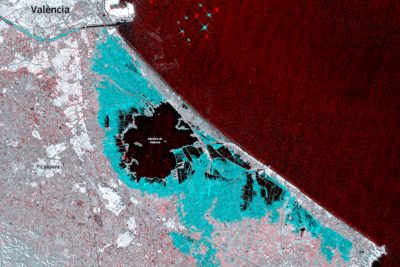
Record rainfall flooded parts of Spain this week, killing more than 150 people in the nation's deadliest natural disaster in decades. New satellite imagery from NASA and the European Space Agency shows the extent of flooding around the coastal region of Valencia.