


NASA Orbiter Spots Curiosity Rover Making Tracks to Next Science Stop
The image marks what may be the first time one of the agency’s Mars orbiters has captured the rover driving. NASA’s Curiosity Mars rover has never been camera shy, having been seen in selfies and images taken from space. But on Feb. 28 — the 4,466th Martian day, or sol, of the mission — Curiosity […]

3 min read
Preparations for Next Moonwalk Simulations Underway (and Underwater)
The image marks what may be the first time one of the agency’s Mars orbiters has captured the rover driving.
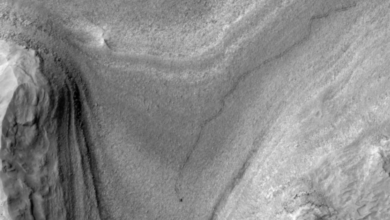
NASA’s Curiosity Mars rover has never been camera shy, having been seen in selfies and images taken from space. But on Feb. 28 — the 4,466th Martian day, or sol, of the mission — Curiosity was captured in what is believed to be the first orbital image of the rover mid-drive across the Red Planet.
Taken by the HiRISE (High-Resolution Imaging Science Experiment) camera aboard NASA’s Mars Reconnaissance Orbiter, the image shows Curiosity as a dark speck at the front of a long trail of rover tracks. Likely to last for months before being erased by wind, the tracks span about 1,050 feet (320 meters). They represent roughly 11 drives starting on Feb. 2 as Curiosity trucked along at a top speed of 0.1 mph (0.16 kph) from Gediz Vallis channel on the journey to its next science stop: a region with potential boxwork formations, possibly made by groundwater billions of years ago.
How quickly the rover reaches the area depends on a number of factors, including how its software navigates the surface and how challenging the terrain is to climb. Engineers at NASA’s Jet Propulsion Laboratory in Southern California, which leads Curiosity’s mission, work with scientists to plan each day’s trek.
“By comparing the time HiRISE took the image to the rover’s commands for the day, we can see it was nearly done with a 69-foot drive,” said Doug Ellison, Curiosity’s planning team chief at JPL.
Designed to ensure the best spatial resolution, HiRISE takes an image with the majority of the scene in black and white and a strip of color down the middle. While the camera has captured Curiosity in color before, this time the rover happened to fall within the black-and-white part of the image.
In the new image, Curiosity’s tracks lead to the base of a steep slope. The rover has since ascended that slope since then, and it is expected to reach its new science location within a month or so.
More About Curiosity and MRO
NASA’s Curiosity Mars rover was built at JPL, which is managed for the agency by Caltech in Pasadena, California. JPL manages both the Curiosity and Mars Reconnaissance Orbiter missions on behalf of NASA’s Science Mission Directorate in Washington as part of the agency’s Mars Exploration Program portfolio. The University of Arizona, in Tucson, operates HiRISE, which was built by BAE Systems in Boulder, Colorado.
For more about the missions, visit:
science.nasa.gov/mission/msl-curiosity
science.nasa.gov/mission/mars-reconnaissance-orbiter
News Media Contacts
Andrew Good
Jet Propulsion Laboratory, Pasadena, Calif.
818-393-2433
andrew.c.good@jpl.nasa.gov
Karen Fox / Molly Wasser
NASA Headquarters, Washington
202-358-1600
karen.c.fox@nasa.gov / molly.l.wasser@nasa.gov
2025-059