Some of the most idyllic places to live in the US have become disaster-prone. Take coastal Florida, most recently battered by Hurricane Milton, and LA's foothills, which battled wildfires that have devastated many neighborhoods.
Alexander de Sherbinin, a Columbia University geographer who specializes in the human impacts of climate change, expects to see a lot of climate migration in the coming years as Americans search for stability.
"Not everybody is necessarily going to go far. But we could see significant movements, probably away from the coasts and toward the north," de Sherbinin told Columbia Magazine.
So, where is safe?
While all US regions will face climate challenges, some areas are more resilient than others.
Property data firm CoreLogic put together a list of the safest ZIP codes in the US based on the firm's Risk Score, which uses property data, replacement costs, and natural hazard insights to determine how weather and climate disasters affect single-family homes financially.
"We combine all of that into the calculation — so it's not just the peril, it's not just the resiliency of the structure," Corelogic principal data scientist Tanya Havlicek told Business Insider. "It's those two things together creating the financial loss."
BI analyzed CoreLogic's data by ZIP code, grouping the safest ones by metropolitan area and highlighting the 10 most populous ones below. The home price data, from Redfin, gives a sense of how much it would cost to buy a home there.
One ZIP code in greater Los Angeles, home to the University of California Irvine campus, appears on the list. It's a pocket of LA that is relatively protected from fires, floods, and earthquakes, said Anand Srinivasan, vice president of research and development at CoreLogic.
Here are 10 metropolitan areas with the lowest risk of climate damage, according to CoreLogic.
10. Spokane-Spokane Valley, Washington
ESB Professional/Shutterstock
ZIP codes on CoreLogic's list: 99203, 99204
What the low-risk ZIPs are known for: The Spokane area has a diverse landscape of hills, plains, prairies, and forests. It is also home to the Centennial Trail, a 40-mile path that runs from Sontag Park in Nine Mile Falls, Washington, to the Idaho state line.
Median home price: $566,000 (99203), $450,000 (99204)
Climate history: Spokane's worst climate event was the 2021 heat dome — lasting from June 26 to July 2 — which resulted in at least 100 deaths throughout Washington state, making it the state's deadliest weather event, according to the Pacific Northwest National Laboratory.
9. San Diego-Chula Vista-Carlsbad, California
San Diego, California.
Thomas De Wever/Getty Images
ZIP codes on CoreLogic's list: 91945, 92007, 92093, 92161, 92182
What the low-risk ZIPs are known for: The San Diego metro area is the second-most populous area in California. The area is near the beach and has a mild climate year-round.
Median home price: $1,524,500 (Carlsbad) 931,000 (San Diego) $812,500 (Chula Vista)
Climate history: In 2007, the Harris Fire burned in San Diego County and destroyed 560 structures.
ZIP codes on CoreLogic's list: 97223, 97080, 97224, 98607, 97304, 97086, 98685, 97003, 97078, 98642, 97015, 98686, 97113, 98606
What the low-risk ZIPs are known for: Hillsboro and Portland are in northeastern Oregon close to the Washington border. Vancouver is just a 15-minute drive north of Portland.
Median home price (Redfin): $520,000 (Hillsboro, OR) $505,000 (Portland) $470,000 (Vancouver)
Climate history: Indland flooding poses the greatest threat in the Portland-Vancouver-Hillsboro metro. The Willamette Valley flood of 1996 was the last and largest flood in Portland history.
7. Los Angeles-Long Beach-Anaheim, California
Los Angeles.
kenny hung photography/Getty Images
ZIP codes on CoreLogic's list: 92617
What the low-risk ZIP is known for: The University of California Irvine campus. It's in a part of the LA metropolitan area that is a somewhat protected nook — neither by the ocean nor in the mountains, and not too close to an earthquake fault line.
Median home price: $1 million (Los Angeles), $826,000 (Long Beach), $896,000 (Anaheim)
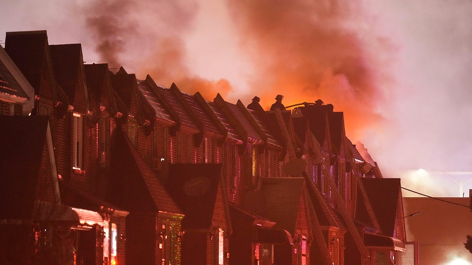
Climate history: The city's warm climate and dry conditions make it prone to wildfires. In January, the Palisades and Eaton fires ignited, tearing through several Los Angeles neighborhoods. They have claimed at least 24 lives and destroyed thousands of homes, making them the city's most destructive fires.
6. Las Vegas-Henderson-North Las Vegas, Nevada
Henderson, Nevada.
Khairil Azhar Junos/Shutterstock
ZIP codes on CoreLogic's list: 89130, 89085
What the low-risk ZIPs are known for:Las Vegas is known globally for its entertainment offerings, but North Las Vegas and Henderson have more suburban lifestyles. Both are within 16 miles of Las Vegas proper.
Median home price: $415,650 (North Las Vegas) $489,900 (Henderson) $444,000 (Las Vegas)
Climate history: Inland floods are the most likely disaster in the Las Vegas-Henderson-North Las Vegas metro, according to CoreLogic. In 1999, Las Vegas received between 1.5 and 3 inches of rain in one day — which is 35% to 75% of its annual amount. The ensuing floods damaged approximately 369 homes.
5. Houghton, Michigan
Houghton, Michigan.
Haizhan Zheng/Getty Images
ZIP codes on CoreLogic's list: 49931, 49913, 49922, 49921, 49805, 49918
What the low-risk ZIPs are known for: Known as the "Gateway to the Keweenaw," Houghton, Michigan, is located along the shores of Lake Superior and is home to Michigan Tech University.
Median home price: $420,000
Climate history: Data from First Street, a climate research company, shows that the city has a low wildfire risk over the next 30 years. However, rainfall could be an issue. In 2018, Houghton experienced its largest flood, with 3 to 7 inches of rain causing major damage, according to the National Weather Service.
4. Hagerstown-Martinsburg, Maryland-West Virginia
A row of homes in Hagerstown, Maryland.
S.G. Floyd/Getty Images
ZIP codes on CoreLogic's list: 25405
What the low-risk ZIP is known for: Known as the "Hub City," Hagerstown is a key commercial and industrial center for the broader tristate area, which includes Western Maryland, parts of South Central Pennsylvania, and the Martinsburg Panhandle of West Virginia.
Median home price: $320,000
Climate history: The Maryland government reported that its cities are vulnerable to climate events like droughts, storms, flooding, and wildfires.
The most recent weather event in the Hagerstown-Martinsburg metro was a winter storm in January, which brought on about 5 inches of snow.
3. Eugene-Springfield, Oregon
Joshua Rainey Photography / Shutterstock
ZIP codes on CoreLogic's list: 97403
What the low-risk ZIP is known for: This pocket of Eugene is home to the University of Oregon campus. The area is surrounded by forests, lakes, and rivers, with many trails for running, biking, and hiking.
Median home price: $610,000
Climate history: Particle pollution — made up of tiny particles like dust, smoke, dirt, and diesel emissions — is the leading environmental concern in the Eugene-Springfield area. In 2024, the American Lung Association ranked the region as the fourth most polluted city in the US.
2. El Paso, Texas
Sean Pavone/Getty Images
ZIP codes on CoreLogic's list: 79925, 79908
What the low-risk ZIPs are known for:El Paso, Texas, is on the western tip of Texas and borders Mexico and is only about 10 miles from New Mexico. El Paso is nicknamed "The Sun City" due to its average of 300 days of sunshine per year.
Median home price: $254,974
Climate history: Even though there is plenty of sunshine in El Paso, its most-likely threat is inland flood. In 2006 El Paso recieved 19.5 inches of rain — double its annual amount — leading to flooding that caused more than $200 million in damage to businesses and homes.
What the low-risk ZIPs are known for: The Detroit-Warren-Dearborn metro is located next to the Detroit River and is a short drive from the Canadian border. Both Dearborn and Warren are suburbs of Detroit, which is one of the least expensive cities to buy a home in the country.
Median home price: $205,000 (Warren) $240,500 (Dearborn) $97,200 (Detroit)
Climate history: The most likely weather crisis taking place is a convective storm, according to CoreLogic's rating. In 2014, Detroit set records by accumulating 94.9 inches of snow during the winter in a deep freeze.


.png)


![‘Companion’ Ending Breakdown: Director Drew Hancock Tells All About the Film’s Showdown and Potential Sequel: ‘That’s the Future I Want for [Spoiler]’](https://variety.com/wp-content/uploads/2025/02/MCDCOMP_WB028.jpg?#)